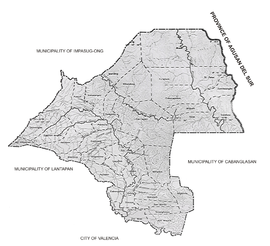
Geographical Location
A. Location and area
-
- Malaybalay City is the capital of Bukidnon Province;
- Around 91 kilometers south of Cagayan de Oro City;
- The first city and the provincial capital of Bukidnon;
- Within the grid coordinates between 8- and 9-degrees North latitude and 125 degrees East longitude.
- Boundaries: East: Pantaron mountain range, West: Municipality of Lantapan and Mount Kitanglad Range National Park (MKRNP), North: Municipality of Impasug-ong, and South: City of Valencia.
- Total land area of 108,258 hectares, (68% forestland, 32% A&D)
B.Topography
- average elevation of about 622 meters above sea level;
- topography is generally sloping, with only about 25% of its area being relatively flat and gently sloping.
- Bigger portion or almost 60% of its total land area has above 30% slope, with steep hills, mountains and cliff-like streamside, and the rest are hilly and rolling.
- City’s landscape is mostly mountainous, of which around 30% areas are still covered with trees and where most of the rivers and creeks originate.
Climate
-
- Fourth type or intermediate B type, that is, with no very pronounced maximum rain period and dry season.
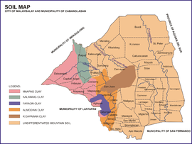
Soil Map of Malaybalay City
The total land area of the city is approximately 108,259 hectares (984.38 km²), that is about 13% of the total area of Bukidnon. An estimated of sixty five percent (65%) of this is classified as forestland/timberland and the remaining thirty five (35%) is alienable and disposable areas (A & D), lands which could be used for various purposes such as for agriculture or for industry.[10]
The city plays a strategic role in the protection of the headwater source of the Pulangi and the Tagoloan rivers because of its location the upper portion of both watershed areas. The Pulangi River then extends through the Cotabato provinces as the Rio Grande de Mindanao and to Cotabato City, where it empties into Illana Bay. The Tagoloan River, on the other hand, traverses northwestward towards Tagoloan, Misamis Oriental, where it joins the Macajalar Bay. These watershed areas provided potable water, irrigation, hydro-electric power and various recreation and tourism activities.